10 June 2011
Cartography: the Russo-Abkhazian border dispute
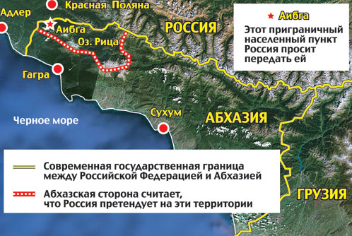
When it was first reported that during the Russo-Abkhazian meetings on border demarcation, Russia had proposed that Abkhazia should cede some 160 sq km of land of its Gagra District, it was unclear exactly what part was meant. Was Gagra itself to be included? Now thanks to an article by Vladimir Vorobin in the Komsomolskaya Pravda we have a map:
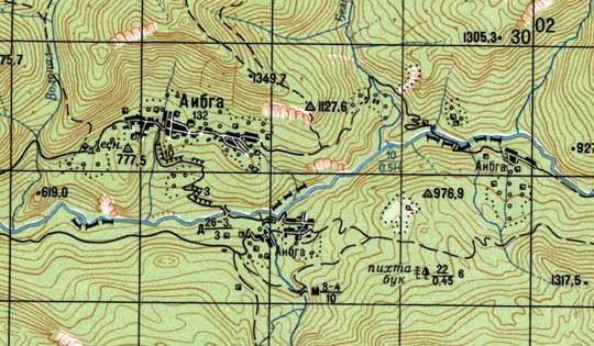
Official statements first denied that the disagreement was over such a large amount of territory, but the head of the Abkhazian delegation, MP Valeri Kvarchia, then confirmed that the Russian side had indeed at first made this 'proposal'. From the second meeting onwards, the dispute instead narrowed on the small village of Aibga, as displayed on this Soviet map (one segment of the grid corresponds to 2 km):
Aibga straddles the river Psou (the thick blue line on the map) which marked the border in Soviet times, dividing Aibga into a northern, Russian and a southern, Abkhazian half. Abkhazia wants to perpetuate this state of affairs, whereas Russia apparently claims the entire village. As can be seen from the map, the amount of land and people involved is very small. Most of Aibga lies north of the Psou. In addition, even the southern half of Aibga is de facto part of Russia, in the sense that by car it can only be reached from Russia, it probably gets all its services from Russia, it is principally inhabited by Russians and there are no border controls on Aibga's two bridges. It would even be a surprise if Aibga was included in the Abkhazian census of last February. Thus if Abkhazia were to give in, it wouldn't lose much in practical terms. But of course, the symbolic impact would be much larger, hence the outrage in Abkhazian society.
The Russian stance in this dispute is puzzling. Russia appears to have no legal arguments for its claims. The 160 sq km of the first proposal would certainly have been a lucrative acquisition. But while the territory is sparsely populated, it does include Lake Ritsa, and it is unthinkable that Abkhazia would give up its principal touristic asset next to its Black Sea coastline. The more recent proposal over Aibga is much more modest, but the lack of practical benefits raises the question, why bother? Why risk permanently alienating your friendly and grateful neighbour, which offers you many lucrative business opportunities, over a tiny, insignificant jot of land? The only plausible explanation that comes to mind is that Russia is using this issue to force concessions in other areas, such as the ownership of Abkhazian land by non-Abkhazian (i.e. Russian) nationals, or Russian influence over Abkhazia's army. (In this context, see Abkhazian Army Purge? - part 3.)

